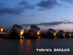
18. Thames Barrier Information & History
The Thames Barrier is the world's second largest movable flood barrier, after the Oosterscheldekering in the Netherlands. Its purpose is to prevent London from being flooded by exceptionally high tides and storm surges moving up from the sea. Early proposals for a flood control system were stymied by the need for a large opening in the barrier to allow for vessels from London Docks to pass through. When containerization replaced older forms of shipping and a new port was opened at Tilbury, a smaller barrier became feasible with each of the four main navigation spans being the same width as the opening of Tower Bridge. The barrier was designed by Rendel, Palmer and Tritton for the Greater London Council. After the 1986 abolition of the GLC it was operated successively by Thames Water Authority and then the National Rivers Authority until April 1996 when it passed to the Environment Agency. More at wikipedia | Read bbc.co.uk | Also read environment-agency.gov.uk >
View Photos of here and nearby locations | Buy Prints